The Drone Solution for Contractors


Quantum Flight Pack
The Perfect Drone Solution for Contractors
You already trust Quantum Land Design as the go-to expert in 3D machine control modeling for the earthmoving industry. Now, we're taking it a step further—giving you the power to unlock precision and efficiency with the Quantum Flight Pack.
The Quantum Flight Pack is designed for contractors who want simple, effective tools without unnecessary complexity. It’s a complete drone solution that works seamlessly with the GPS system you already own, ensuring your data aligns perfectly with your machine control models and project plans every time.
No Subscription Fees, Just Results
We believe in keeping things simple. With Quantum, you pay only for the data we process—no subscriptions, no hidden fees, no hassle. You get accurate, actionable data when you need it, without paying for anything you don’t.
Here’s How It Works:
-
Place a Few Ground Control Targets: Use your GPS rover to set control points on the site.
-
Fly Your Drone: Let the automated flight software handle the heavy lifting.
-
Upload Your Data: Load your photos and control points into our secure cloud.
-
Let Quantum Do the Rest: We’ll process the data and deliver precise volume calculations, 3D surfaces, or contours ready to integrate into your favorite software tools (AgTek, Trimble Business Center, Topcon Magnet, InSite, AutoDesk, Bentley, and more). We aim to deliver your drone data results within in 3 business days - just like our machine control model services.
No complicated software to learn. No expensive subscription web portals to navigate. Just real-time, reliable data you can use in your current workflows.
Flexible Pricing and Transparent Quotes
We bill by the project and are happy to provide upfront pricing, so you’ll always know the cost before we begin. And the best part? You’re never charged unless you send us data to process.
Training Made Easy
Whether you prefer onsite training or want to jump right in with our free YouTube tutorials, we’ve got you covered. Supplemented with a quick phone call, you’ll be ready to fly in no time.
Take Control of Your Jobsite Data
Click here to learn more and request a personalized quote. Discover how the Quantum Flight Pack can help you make better decisions, improve your bids and secure full payment for change orders — boosting your bottom line.
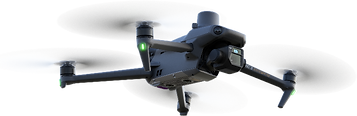
Quantum Flight Pack - PPK/RTK
The Quantum Flight Pack - PPK/RTK is the only drone solution you’ll need for precise, efficient, and seamless data capture on your construction sites. Tailored for both frequent flyers and complex project environments, this kit includes everything you need to get started immediately.
What’s Included:
-
DJI Mavic 3E drone
-
RC Pro remote with a built-in screen
-
PPK/RTK GPS antenna for enhanced accuracy
-
Four high-capacity drone batteries
-
Contractor-grade carrying case
-
Eight ground control targets
-
One year of DJI Enterprise Care
-
Comprehensive accessories for a fully operational kit
Each Quantum Flight Pack is meticulously updated, test flown, and verified with a processed data set to ensure it meets the highest standards right out of the box.
Here's a quick video showing what's included in our Flight Pack.
Simple Operation with Powerful Results
The RC Pro remote comes pre-installed with DJI Pilot 2 software, a free and user-friendly application designed for construction professionals. Planning an automated flight takes just minutes, enabling fast and efficient data collection.
You’ll use your existing GPS rover to measure ground control points and check shots, ensuring your drone data aligns seamlessly with your machine control models, takeoff software, and project plans. The system is designed for total integration into your current workflow.
PPK and RTK Capabilities for Maximum Precision
With the PPK/RTK module attached, the Quantum Flight Pack automatically logs PPK (Post Processing Kinematic) data during flights, offering significant improvements in GPS accuracy. For RTK (Real-Time Kinematic) corrections, simply connect to an NTRIP network or a local base station. Your state may offer a free-to-use NTRIP network - often managed by the DOT.
This system provides:
-
Increased flexibility in ground control target placement
-
Time savings for large or hard-to-access sites
-
Accurate photo GPS locations to streamline post-processing
At Quantum, we will post-process your PPK data to perfect alignment with your machine control models and ensure flawless integration into your workflows.
Hassle-Free Pricing and Support
Remember, we offer transparent per-job billing with no hidden subscription fees. Training is easy, too. We'll come to your site or access our free resources on YouTube, with additional phone support to get you flying confidently.
Whether you’re capturing drone data for 3D surfaces, contours, or volume calculations, the Quantum Flight Pack ensures precision and ease every time.
For more information or to request a quote, click here to tell us about your needs, and we’ll reach out to discuss how the Quantum Flight Pack can transform your operations.
FAA Requirements
You will need an FAA Part 107 drone pilot certificate to fly for your business. It's a written test only. Here are four great resources to study before the test:
-
The ASA Remote Pilot Test Prep Book (this is included in your Quantum Flight Pack)
-
Tony and Chelsea Northrup's YouTube video
-
Highly recommended free video course, older but still relevant
-
-
Altitude University Part 107 YouTube video
-
Another highly recommended free video course
-
-
The FAA Become a Drone Pilot Site
-
Follow the first-time pilot instructions, unless you already have a pilots certificate.
-
This link will take you to the Official FAA Part 107 study materials.
-
-
xyHt Magazine "How to Get a Drone License" This article will answer most of your questions, even some you did not know you had.
Studying and passing the FAA test might seem overwhelming or time consuming, but it's not that difficult. Most of our contractor clients study over a one or two week period, take the test and pass it on the first try. We have not had a single contractor fail to obtain their Part 107 certificate.
PPK/RTK Flight Pack