


Drone Surveying in Construction: Simple, Effective, and Cost-Efficient
Drones simplify construction surveying with just a GPS base/rover and a drone. Affordable, reliable data without the complexity.


ConExpo-Con/Agg Radio Podcast
The folks at ConExpo put out a monthly podcast you might enjoy. It features experts from the industry discussing a wide range of topics. E

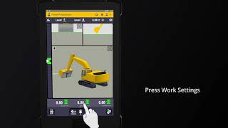
Trimble Earthworks Tutorials
Learn how to use your Trimble Earthworks 3D grade control system.
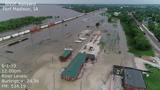
BNSF Rail Yard Flood
The Quantum Flight Pack is not just for topo flights. Here, it documents flooding conditions at the Mississippi River's crest in a raily
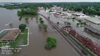
Mississippi Flood Documentation
Mississippi flood crest documentation.


Structurally Correct
The most progressive contractors are moving to 3D modeling for their structural excavations, just like they use a 3D surface model to grade


Single Point GPS Site Control: How to Ensure Accuracy & Avoid Errors
Avoid common pitfalls with Single Point GPS site control—learn to ensure stable, accurate results and avoid costly mistakes in grading.


Hitachi Grade Guidance
Hitachi now offers a factory-integrated Grade Guidance system. They offer an open architecture for aftermarket kits from Topcon, Trimble and


