


How to Use Drones in Your Earthmoving Business
Are you ready to take your earthmoving business to the next level? Join me at Trimble Dimensions 2024.

Zach Pieper


Ground Control - Principle 4
Ground control points put your drone data in the right location. Check shots are what prove it's actually accurate. Collect them between GCPs, at tie-ins and flowlines, and any critical elevation areas. Any check shot is better than none, and they add almost no time to your field work.
Zach Pieper


Ground Control - Principle 5
ALWAYS, and only, measure in your ground control with a rover that is fully calibrated to the site control for your GPS system.
Zach Pieper


Ground Control - Principle 3
To start, place a GCP on roughly the highest and lowest spots on your project. Don't worry about...
Zach Pieper


Ground Control - Principle 2
Surrounding your site with ground control is the step that does most of the heavy lifting. Four to six GCPs placed near the outer boundary will box in your drone data and lock it to your machine control model. Here's how to lay them out for any site shape, road, or levee.
Zach Pieper


Ground Control - Principle 1
Where you place your ground control points matters as much as how you measure them. Overhead obstructions, grade changes, and bad surface choices can knock a GCP out of your data entirely. Here's what to look for before you set a target.
Zach Pieper
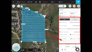
DJI Drone Camera Settings for Mapping and Survey
Quality pictures are required to get the best from your drone data. Here is a quick video showing you how to set up the camera on your DJI
Zach Pieper


American Flat Track
Machine control models aren't just for commercial projects. Quantum's experts improved a problem jump and fixed track drainage issu
Zach Pieper


Drone Surveying in Construction: Simple, Effective, and Cost-Efficient
Drones simplify construction surveying with just a GPS base/rover and a drone. Affordable, reliable data without the complexity.
Zach Pieper
Quantum Flight Pack - Flight Planning Video
Supplement your GPS machine control system with Quantum's Flight Pack drone system. In this video you will learn how to plan a topograp
Zach Pieper


